HISTORY153 - Isthmus of Tehuantepec
Recently I gave a talk at the Hacienda at the Canyon retirement community in which I live about my Great Grandfather Eugene Ring’s adventures during his unplanned travels to the California Gold Rush in 1848 - 1850. Part of those travels included crossing southern Mexico’s Isthmus of Tehuantepec (see map below), under duress, in 1850, after being abandoned with nine other shipmates on the Pacific coast by his sailing ship while they were ashore looking for much-needed water. (For those interested, my Great Grandfather’s memoir of his complete travels is attached.)

The Isthmus of Tehuantepec is a narrow land bridge in southern Mexico.
After giving my presentation, I
realized that there was still a lot I didn’t know about the overall history of
this fascinating place where my Great Grandfather was so sorely
tested. So, this blog will cover the
History of the Isthmus of Tehuantepec.
After an introduction, I will
discuss the Isthmus’s early Mesoamerican civilizations, the Spanish conquest
and colonial period, and its Mexican history after independence. The history will be dominated by the
importance of the Isthmus of Tehuantepec as an interoceanic transportation
route between the Gulf of Mexico and the Pacific Ocean.
As usual, I will list my
principal sources at the end.
Introduction
At its narrowest point, the Isthmus of
Tehuantepec spans only 124 miles between the Gulf of Mexico (Atlantic Ocean)
and the Gulf of Tehuantepec (Pacific Ocean).
The Isthmus serves as a natural geographic break between North America
and Central America.
The Isthmus features a low plateau, formed
where the Sierra Madre Mountain chain breaks down into a plateau-like ridge,
with a maximum elevation of only 735 feet. The climate is hot overall. The northern (Atlantic / Gulf of Mexico) side
is a swampy, humid tropical jungle, while the southern (Pacific / Gulf of
Tehuantepec) side is typically significantly drier and windswept.

Topo map of the Isthmus of Tehuantepec.
I’m including a contemporary map of
the Isthmus of Tehuantepec here so that I can reference specific locations.

Contemporary map of the Isthmus of Tehuantepec.
Early Mesoamerican Civilizations
The
Olmec civilization (1200 - 400 BC) flourished on the northern tropical lowlands
of the Isthmus of Tehuantepec - a region that contains today’s towns of
Coatzacoalcos and Minatitlan. As
Mesoamerica’s first major complex culture, they built massive river-valley
centers, traded rare luxury materials, and established foundational religious
and artistic traditions for later societies.
River
centers featured massive earthen platforms, complex drainage systems, large
pyramids, intricate jade offerings, ritual tombs and the iconic multi-ton
basalt colossal heads. Residents
flourished by farming rich alluvial soils along flooded river networks while
harvesting abundant aquatic and forest resources. They traded carved local goods, rubber, and
feathers outward to the Valley of Mexico, Oaxaca, and Central America in
exchange for obsidian, iron ore/hematite, and jade. They carved basalt boulders (transported from
distant volcanoes) into colossal human heads and royal thrones. Religious life centered around a cosmos
divided into levels and a powerful transformation cult linking humans and
jaguars. The Olmecs standardized
early writing, calendar systems, and sacred architecture that deeply influenced
successor civilizations like the Zapotec and Maya.

Carved from massive basalt boulders and transported over long distances, each head depicts a distinct individual wearing a helmet-like headdress, possibly representing rulers or elite warriors.
The
Zapotec civilization was one of the earliest and most enduring pre-Columbian
societies in Mesoamerica, ruling over the Valley of Oaxaca in southern Mexico
for nearly 3,000 years. Emerging around
500 BC, they developed a highly advanced culture known for its monumental
architecture, early writing system, and complex urban planning.
In
their Formative Period (500 - 200 BC), the Zapotecs consolidated
separate valley communities, and established their capital atop a leveled
mountain called Monte Albán, near today’s Oaxaca City (see first map above). It became one of the first true cities in
North America. During this era, the
Zapotecs developed one of the continent's earliest written scripts
(hieroglyphics) and a highly accurate 260-day ritual calendar.
During
the Classic Period (c. 200 BC - 700 AD), Monte Albán grew into a massive
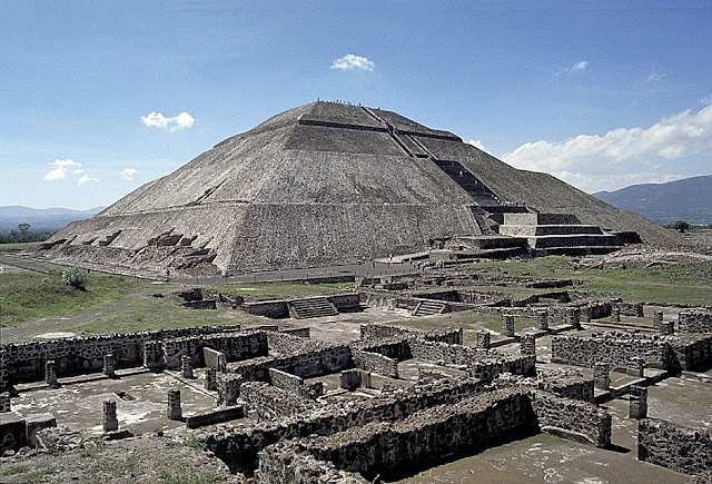
urban metropolis, home to an estimated 25,000 to 30,000 people. The Zapotecs controlled most of the Oaxaca
Valley and exerted significant influence across Mesoamerica. They built vast stone plazas, pyramids, ball
courts, and elaborate underground tombs reserved for royalty and elites.

Ruins of the Zapotec capital city of Monte Albán in the Oaxaca Valley.
In the Post-Classic Period (c. 700 CE - 1521
AD), Monte Albán was slowly abandoned due to economic decline, environmental
pressures, and political fragmentation. In the 14th century, the Zapotecs expanded
south and east from the Valley of Oaxaca to the southern lowlands and coastal
plains of the Isthmus of Tehuantepec, creating major urban centers near today’s
cities of Tehuantepec and Juchitán. They successfully withstood a major invasion
by the Aztecs in the late 15th century. Later, hearing of the Aztecs defeat by
Spanish conquistadors in 1519 -1521, the Zapotecs initially opted for strategic
diplomacy and alliances rather than costly warfare.

Recently discovered ruins of the Zapotec city of Guiengola, located in the southern part of the Isthmus of Tehuantepec about seven miles northwest of today’s city of Tehuantepec. The city flourished from 1350 - 1500 AD, and featured over 1500 structures, including a main plaza, residential quarters, defensive walls, dual cylindrical astronomical structures, and an elite "Palace" complex.
Spanish
Colonial Period: 1521 - 1821
The Spanish conquest of Mexico began in 1519 when Conquistador Hernán Cortés landed on the Gulf Coast and marched inland with a small force. By forging local indigenous alliances, exploiting internal empire rivalries, and utilizing the devastating impact of European diseases, the Spanish overthrew the Aztec Empire in 1521. The Aztec capital, Tenochtitlan, was razed and rebuilt as Mexico City, becoming the colonial capital of the Viceroyalty of New Spain.
Shortly after defeating the Aztecs, in
1522, Hernán Cortés sent forces south to the Valley of Oaxaca and the Isthmus
of Tehuantepec. Zapotec
rulers chose mostly to submit or negotiate rather than face total annihilation,
allowing the Spanish to establish garrisons quickly.
Given its narrow interoceanic land bridge, the Spanish Crown and Cortés prioritized the Isthmus to establish a route from the Atlantic side to the Pacific to explore the western coast of Mexico and California, connect New Spain to Peru, and eventually begin exploration across the vast Pacific.
Initially they transported goods by river and
overland from the Atlantic side to the Pacific, using the navigable part of the
Coatzacoalcos River for roughly two-thirds of the transit (from the Atlantic
side), with the remaining gap (to the Pacific side) crossed via overland trails
using local indigenous labor and pack animals.

The Coatzacoalcos River can be traced south from the Gulf of Mexico on this Spanish-language map of rivers in the Isthmus of Tehuantepec.
In 1529, Hernán Cortés secured
lands in the Isthmus of Tehuantepec as part of a vast personal land grant
awarded to him by King Charles V of Spain.
The land included the strategic town of Tehuantepec, near the Pacific
coast, and land around the town of Santa Maria Jalapa, a few miles northwest of
Tehuantepec. The Santa María territory
spanned roughly 210 square miles, and included seven major
haciendas. While not exclusively his
private property, Cortés also controlled parts of the surrounding river corridors
to facilitate an interoceanic transit route.
To enhance future explorations on the Pacific side of the Isthmus, in the early 1530s, Hernán Cortés himself established a ship-building facility, called El Carbón, located at the mouth of the Tehuantepec River near the town of Tehuantepec. While the area was rich in local timber, all other critical shipbuilding components (such as ironwork, anchors, rigging, and sails) had to be transported from Spain across the Atlantic to Veracruz, hauled up the Coatzacoalcos River in canoes, and carried by Indigenous natives across the rugged Isthmus of Tehuantepec.
Under these difficult circumstances,
sailing ships were built at El Carbón for roughly a decade. The ships were used to explore the western
coast of Mexico and California, establish early trade routes with Peru, and
attempt trade expeditions to the spice-rich Moluccas Islands, China, and
Japan. But, because of the immense
logistical challenges, high costs, and the changing strategic priorities,
shipbuilding at El Carbón ceased by approximately 1540, as Cortés shifted
operations to a more practical Pacific ports like Acapulco.
Following Cortés's death in 1547, the
management of his Isthmus of Tehuantepec holdings by members of his family,
shifted aggressively toward profitable cattle ranching. The beef supplied local markets, while lucrative
exports of tallow and tanned hides were shipped down to Peru. The southern coast of the Isthmus allowed the
Cortés estate to dominate lucrative salt production, utilizing indigenous labor
to harvest coastal lagoons.
Because of the Isthmus's incredible
geographic value as a potential interoceanic transit route, the Spanish Crown
grew wary of a single feudal lord controlling it. In 1560, King Philip II of Spain issued a
Royal Decree officially revoking the port of Tehuantepec from the land grant
and returning it to direct Crown control. In exchange, Cortés’s heirs were compensated
with a perpetual annual payout of gold and maize equivalent to the city’s tax
tributes.
Unlike other regions where the local
population was completely displaced, the Isthmus retained a deeply rooted
Indigenous social structure. The town of
Tehuantepec remained a major cultural epicenter. The local Zapotec population maintained an
active, resilient society. Over the
generations, a unique cultural dynamic flourished where women dominated local
marketplaces and commerce, laying the foundations for the area's famous
matriarchal reputation.
The region's economy relied heavily on
cattle ranching, plus red dye, obtained from cochineal soft-bodied
insects, and blue dye cultivated from the indigo plants, which were highly
prized by European textile markets.
The late 18th century
brought a renewed wave of scientific exploration. In 1771, the Spanish Crown executed
the first highly detailed engineering survey of the Isthmus. Engineers evaluated the topography to see if
a sea-level canal could finally link the Gulf of Mexico to the Pacific. In 1814, the Spanish parliament passed a
formal decree authorizing the official construction of an interoceanic canal
across the Isthmus of Tehuantepec.
However, Spain’s financial exhaustion from the Napoleonic Wars and the
looming Mexican War of Independence prevented any action.
Geopolitics and Concessions (1821 - 1876)
Following the end of Spanish rule in
1821, successive Mexican governments recognized the strategic value of the
Isthmus. Early administrations conducted
geological surveys, initially envisioning an interoceanic canal. However, early projects repeatedly stalled
due to Mexico's severe economic crises and chronic political instability.
·
The Garay Concession (1842): The
Mexican government granted Don José de Garay a concession (permission) to build
a cross - Isthmus route. He proposed a
mix of river navigation and a canal.
However, funding issues and political instability stalled the project.
Global superpowers also quickly
recognized that controlling the Isthmus of Tehuantepec could revolutionize
international trade.
·
Initial U.S. Encroachment:
Following Mexico’s defeat in the Mexican - American War in 1848, the United
States aggressively sought control over the Tehuantepec route. During the Treaty of Guadalupe Hidalgo
negotiations, U.S. diplomats offered an additional $15 million specifically to
secure transit rights across the Isthmus, which Mexico flatly rejected to
protect its sovereignty.
It was during this period,
specifically in December 1850, that Eugene Ring, experienced his great
adventure crossing the Isthmus of Tehuantepec.
Three of his shipmates died of cholera, but Eugene and six of his mates
survived a month-long trek across the undeveloped Isthmus to catch a ship in
Veracruz to get back to the United States.
· The McLane-Ocampo Treaty (1859): Amidst Mexico's bitter War of Reform, the liberal government of Benito Juárez signed a treaty that would have granted the U.S. perpetual right of transit across Tehuantepec. But the U.S. Senate failed to ratify the treaty due to looming American Civil War tensions.
·
The Tehuantepec Turnpike: A
primitive dirt stagecoach road across the Isthmus was completed by a U.S.
company in the late 1850s, providing an early temporary overland route for
passengers, cargo, and mail.
As technology advanced, engineers
realized a canal through the rugged Chivela Pass (see topo map above) would be
too costly. Instead, focus shifted to a
trans-isthmus railway. Prior to
1876, several attempts by American and Mexican companies to build a railway
across the Isthmus of Tehuantepec failed due to political instability, funding
shortages, and regional wars
The Railway Boom (1876 - 1914)
The year 1876 marked a major turning
point for the Tehuantepec railroad project, coinciding with General Porfirio
Díaz rising to power in Mexico. Upon
taking the presidency, Díaz shifted Mexico’s economic strategy from granting
railroad concessions to foreign businessmen, to deciding that Mexico had better
take control, transforming the long-desired trans-isthmus route into a national
priority.
· The Original Line: A basic rail line across the isthmus was eventually cobbled together and structurally completed by 1894. However, the terminal ports were deficient in facilities and the railroad was too light for heavy traffic and heavy interoceanic cargo.
·
Final Completion (1907): Díaz
eventually hired British engineer Sir Weetman Pearson to completely rebuild the
line and modernize its flanking ports. President
Porfirio Díaz inaugurated the Tehuantepec Railroad and the modern port
facilities at Coatzacoalcos (north) and Salina Cruz (south) in 1907.

The route of the 1907 cross-Isthmus railroad from the northern port (right side of this Spanish-language map) to the southern port (left side).
The route became a massive success
overnight, routing over 850,000 tons of international cargo annually, and
hosting dozens of trains per day. The
boom fueled rapid population growth and urbanized the terminal port
cities. It shaved thousands of miles off
the treacherous journey around Cape Horn for international cargo ships. The railroad was a primary shipping route for
American goods moving between the coasts and Hawaii.
The railway was immensely profitable - until
1914 - when the combination of the Mexican Revolution, World War I, and the
inauguration of the Panama Canal severely limited its usefulness.
· Mexican Revolution & WWI: Domestic warfare disrupted Mexican infrastructure, while World War I shifted global shipping priorities.
·
The Panama Canal (1914): The
opening of the Panama Canal allowed ships to transit between oceans without
unloading their cargo onto trains.
Panama’s narrower width made it the globally preferred route.
Decades of Stagnation and Local
Integration: 1915 - 1970s
For
most of the mid-20th century, the international trade corridor of
the Isthmus of Tehuantepec sat largely forgotten by global markets.
· Local Economy: The region's railway was relegated to a secondary role, sustaining only local passenger and agricultural trade. The region lagged behind northern Mexico socioeconomically. Despite the lack of industrial growth, towns like Tehuantepec and Juchitán remained deeply important centers for indigenous Zapotec culture and matriarchal commerce.
·
Failed Proposals: The Mexican government repeatedly floated ideas to
revitalize the route. In the 1940s,
planners proposed an "interoceanic ship railway" capable of carrying
ships on massive wheeled cradles, but the booming size of post-WWII cargo ships
rendered the proposal obsolete.
The Petroleum Pivot: 1970s - 1990s
While
international interoceanic transit stayed dormant, the Isthmus found a new
economic purpose through Mexico's mid-century oil boom.
·
Petrochemical
Expansion: The Mexican
government heavily invested in local infrastructure to support the state-run
oil company, PEMEX. Major oil refineries
and petrochemical complexes were constructed in Minatitlán, Coatzacoalcos, and
Salina Cruz.

The Isthmus of Tehuantepec’s largest oil refinery at Salina Cruz.
·
Privatization
Trajectory: In 1999,
following the nationwide privatization of the Mexican rail network, the
government founded the state-owned enterprise Ferrocarril del Istmo de
Tehuantepec to maintain control of the core trans-isthmus tracks, though
the infrastructure continued to slowly deteriorate over the following decade.
The Wind Power Boom: 2000s - 2017
In
the early 21st century, the Isthmus was reassessed not just for its
geographical narrowness, but for its climate.
The La Ventosa region of the Isthmus, in
the south near the municipality of Juchitán, and just
north of the Pacific coast and the Gulf of Tehuantepec, features some of the highest and most consistent wind
speeds in the world.
·
Green Energy
Frontier: Beginning in the
mid-2000s, massive foreign and domestic private investments flooded the region,
transforming the landscape into Latin America’s densest wind-energy corridor,
eventually erecting more than 2,000 wind turbines.

Wind turbine farm in the southern Isthmus of Tehuantepec.
·
Social Conflict: This rapid expansion triggered severe land disputes,
as indigenous communally-owned farms were fenced off, sparking decades-long
legal and social resistance regarding territorial sovereignty and indigenous
rights.
In 2011, Pat and I, successfully traced my Great Grandfather’s 1850
trek across the Isthmus of Tehuantepec, from Salina Cruz to Coatzacoalcos. We hired a Mexican guide for the automobile
trip (road completed in 1960) across the Isthmus, following Eugene’s detailed
daily account in his memoir.
The Interoceanic Corridor (2018 - Present)
In
2018, newly elected Mexican President Andrés Manuel López Obrador officially
resurrected the century-old vision of Porfirio Díaz. Confronted with severe droughts and
bottlenecks plaguing the Panama Canal, Mexico revived the "dry canal"
concept.
The
government launched the Interoceanic Corridor of the Isthmus of Tehuantepec Project. Designed as a modern logistics network,
this multi-billion dollar initiative set out to fully rehabilitate the 1907
railway, modernize the deep-water ports of Coatzacoalcos and Salina Cruz, and
establish a network of industrial parks.
This marked the official pivot of the Isthmus from an underutilized
domestic corridor back into a primary contender for global maritime logistics.

Since
its start, the project has received massive public investment - around $4
billion - from the administrations of President Obrador and his successor
Claudia Sheinbaum. It has also
attracted $1 billion in projected private funding. Alongside the railways, the government plans
to create “development poles,” industrial parks designed to attract private
investment in specific sectors including semiconductors, pharmaceuticals,
automotives, and clean energy, among others.
Companies including Mota-Engil México, Grupo Carso, and ProIstmo have
already been granted licenses to develop them.
|
Feature |
1907 Historic Railway |
Present Interoceanic Corridor |
|
Primary Route |
Coatzacoalcos to Salina Cruz |
Coatzacoalcos to Salina Cruz |
|
Inauguration |
1907 (Porfirio Díaz) |
December 2023 |
|
Services Offered |
Heavy Freight |
Modernized Freight & Scheduled
Passenger Trains |
|
Broader Scope |
Single isolated rail line &
basic ports |
Network of 10 industrial parks, 4
modernized ports, & expanded highway corridors |

Passengers alight in Matías Romero, Oaxaca, from the new Tehuantepec Interoceanic Train.
Because
the project connects two major ports and its backbone will move maritime cargo
between them, the project is administered by the Mexican Navy, which provides
security for railway operations and industrial park construction. Policymakers have promised abundant energy
and water resources for investors.
While
the multi-billion dollar project aims to bridge the economic gap between
northern and southern Mexico, it remains controversial. Local indigenous communities continue to
voice deep concerns over environmental degradation, deforestation, and the
forced industrialization of their ancestral communal lands.
Pat and I are very happy to have learned
all this historic background about the area of my Great Grandfather’s great
adventure (and ours, 161 years later).
Sources
My principal
sources include: “Isthmus of Tehuantepec,” “Zapotec Civilization,”
“Interoceanic Corridor of the Isthmus of Tehuantepec,” “Juchitan de Zaragoza,”
and “Marquessate of the Valley of Oaxaca,” Wikipedia.com; “Isthmus of
Tehuantepec,” encyclopedia.com; “Mexico’s Answer to the Panama Canal Finally
Takes Shape,” americasquarterly.org; plus, numerous other online sources,
including answers to many queries using Google in AI-Mode.

Comments
Post a Comment