FAMILY7 - Our Favorite Photos of Scenic Arizona
In my last blog (posted February 23, 2024), I shared photos that Pat and I have taken over the years from our backyard in Tucson. That article drew a big response, so I decided in this blog to share some of our favorite photos of scenic Arizona locations.

For this purpose, I’ve divided
the state into three sections: southern,
central, and northern. I’ll group our
photos in these regions, according to the scenic locations we visited. For reference, I include a map of Arizona
below:

Southern Arizona
Ranging from the Mexican border
to Phoenix, this section includes photos from Bisbee, Chiricahua National
Monument, Sells, Tumacácori, San Xavier, Tucson, and Phoenix

My mother grew up in Bisbee. This is Bisbee’s famous Copper Queen Hotel.
 |
| View from the picturesque trail at Chiricahua National Monument. |
 |
| We drove to Sells (66 miles west of Tucson) one day to see the annual Sell Rodeo. |

Mission San Jose de Tumacácori (10 miles south of Tucson) - founded by Jesuit Father Eusebio Kino in 1691.

Mission San Xavier del Bac - founded in 1692 by Father Eusebio Kino.
 |
| The entrance to Tucson’s Sabino Canyon, just a couple of miles from our house. |
 |
| Fall colors on Mount Lemmon, northeast of Tucson. |
 |
| Aravaipa Creek in Aravaipa Canyon, just north of Tucson. |

Sculpture in glass at the entrance to Phoenix Botanical Gardens.
 |
| Pat took this close-up at the Butterfly Exhibit at Phoenix Botanical Gardens. |
Central Arizona

Looking south from the Mogollon Rim.
 |
| Watson Lake Park in Prescott. |

The red rocks of Sedona from an overlook on Schnebly Hill Road.
 |
| Cathedral Rock formation in Sedona. |

Sedona’s Cathedral Rock in background.

Sunset at Cathedral Rock.
 |
Yellow aspen tree forest on
Flagstaff’s Humphrey’s Peak. |

Our favorite Fall walking trail on Humphrey’s Peak.
Northern Arizona
Extending from Flagstaff to
Arizona’s border with Utah, this section includes photos from Wupatki National
Monument, Antelope Canyon, Havasupai Indian Reservation, the Grand Canyon -
South Rim, the Grand Canyon - North Rim, Lee’s Ferry, the Painted Desert,
Petrified Forest National Park, and Canyon de Chelly National Monument.
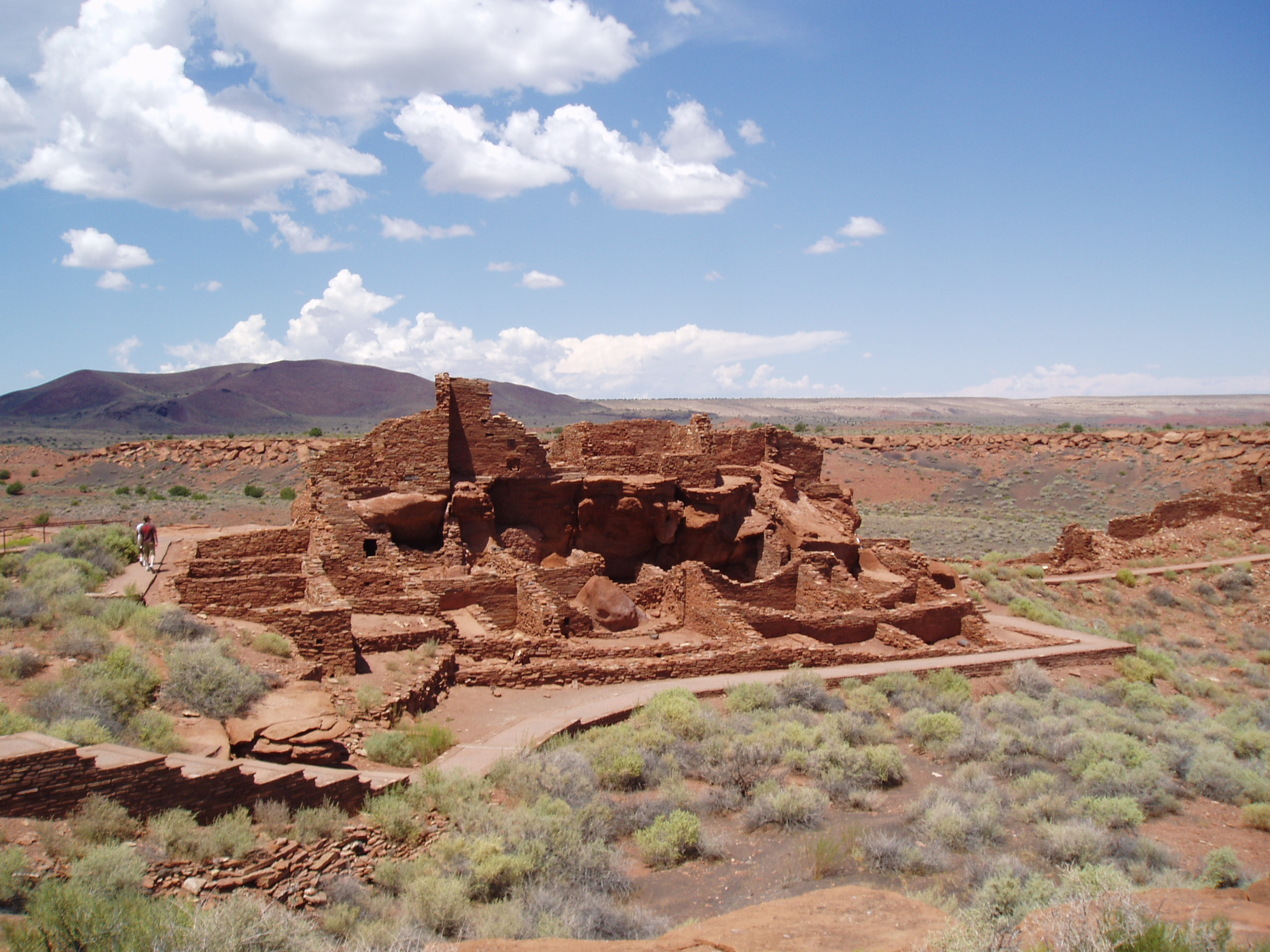
Native American ruins at Wupatki
National Monument.

| Underground display of beautiful colored rock at the Navajo’s Antelope Canyon. |
 |
| Pat attended a luxury camping trip / photography workshop at Havasupai Campground at the bottom of the Grand Canyon. This is Havasupai Falls. |
 |
| Part of Little Navajo Falls. |

Falls and swirling waters near Havasupai Campground.
 |
| View from the South Rim of the Grand Canyon. |

South Rim view of Colorado River.
 |
| Shadows at sunset on South Rim. |

South Rim view of Desert Tower and Colorado River entering Grand Canyon.
 |
| View from Desert Tower of light rain and rainbow. |

Bob and Pat contemplate the Grand Canyon from Desert Tower.
 |
| North Rim view of Grand Canyon from Bright Angel Point. |
 |
Sunrise view from Point Imperial on the
North Rim. |
 |
| Early morning North Rim view of Angel's Window near Cape Royal. |

Bob and Pat mesmerized by the Grand Canyon near Angel Point on North Rim.
 |
| Lee’s Ferry - the only place in hundreds of miles from which one can easily access the Colorado River from both sides. |

The Painted Desert in northeastern Arizona.
 |
| Native American petroglyphs in the Painted Desert. |

Three-dimensional formations in the Painted Desert.
 |
| Petrified bridge (with concrete support) in Petrified Forest National Park. |

Petrified logs at Petrified Forest.
 |
| Monument Valley’s East Mitten Butte at sunset. |

Framed hazy view of distant Monument Valley formations.
 |
| Totem pole formations in Monument Valley. |

Canyon de Chelly in northeastern Arizona.
 |
Native American “White House” ruins in Canyon de Chelly. |

Comments
Post a Comment