Posts

HISTORY32 - South America: Part 2 - European Colonization

Image
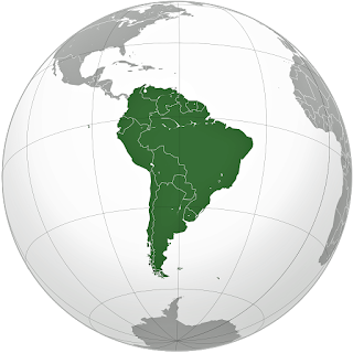
This article is Part 2 of my 3-part history of South America.  Part 1 covered the continent’s geologic evolution through pre-Columbian civilizations.  Part 2 covers European colonization.  Part 3 will cover the independence period through today.   In 1494, within two years of Columbus’s discovery of the Americas, Spain and Portugal, the two great maritime powers of that time, on the expectation of new lands being discovered in the West, signed the Treaty of Tordesillas, by which they agreed that newly discovered lands outside Europe should belong to the two countries.  The Treaty established an imaginary line along a north-south meridian, roughly 46° 37' West.  In terms of the treaty, all new lands to the west of the line (which is now known to take in most of South America), would belong to Spain, and all new lands to the east, to Portugal. In the 1494 Treaty of Tordesillas between Spain and Portugal, Spain was allotted all new lands west o...

HISTORY31 - South America: Part 1 - Pre-Columbian

Image
This, and my next two articles, complete a series of histories of the major countries and continents in the Western Hemisphere.  This is Part 1 of the history of the continent of South America, covering geologic evolution through pre-Columbian civilizations.  Part 2 will cover European colonization.  Part 3 will cover the independence period through today.   Introduction South America is the world’s fourth largest continent after Asia, Africa, and North America, with a land area of 6,890,000 square miles.  It is bordered on the west by the Pacific Ocean and on the north and east by the Atlantic Ocean.  North America and Caribbean Sea lie to the northwest, with Antarctica to the south.  The continent was named in 1507 by cartographers Martin Waldseemuller and Mathias Ringmann after Amerigo Vespucci, who was the first European to suggest that the Americas were not the East Indies, but a new World, unknown to Europeans. South America is a continen...

HISTORY30 - Antarctica

Image
  This article is about the history of Antarctica.   My previous articles on the history of various places in the world, and the history of maps, showed me that I knew virtually nothing about Antarctica.   It’s time to correct that. Map of the southern hemisphere showing Antarctica in relation to the closest other continents.     My primary source for this article is Antarctica / History, Animals & Facts / Britannica , supplemented with numerous other online sources. Natural Landscape Antarctica is the world’s fifth largest and southernmost continent.   It is also the world’s highest, driest, windiest, coldest, and iciest continent. Antarctica is about 5.5 million square miles in size, and thick ice covers about 98 percent of the land.     The average elevation of Antarctica is about 7,200 feet, with the highest peak, Mount Vinson, in the Ellsworth Mountains, at 16,050 feet.   The continent is divided into East Antarctic...